Strategy to reduce Hobart's bushfire risk
Published on 04 June 2021
Protecting Hobart and its community from the risk of bushfire is the aim of an updated bushfire management strategy that is currently open for public comment.
The draft Bushfire Management Strategy 2021 includes an overview of Hobart’s bushfire risk and the methods used to reduce it. The strategy draws from the findings of the recent Royal Commission into National Natural Disaster Arrangements and from the experiences of Tasmanian fires in 2016 and 2018-19.
“Bushfire is considered the greatest single threat to the Hobart area,” Lord Mayor Anna Reynolds said. “We know from past bushfires just how devastating the impacts can be.”
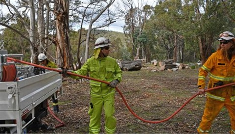
“The City of Hobart takes steps to reduce the risk through things like fuel reduction burns, fuel breaks and maintenance of fire trails.”
In 2010, a report by the Antarctic Climate and Ecosystems Cooperative Research Centre warned that southeast Tasmania, including the Hobart area, was subject to the highest fire danger in the state. Unlike the rest of Tasmania, the Derwent Valley and south-east Tasmania regularly experience extreme to catastrophic Fire Danger Ratings. The Hobart region is also one of the driest parts of Tasmania.
The draft bushfire management strategy warns that bushfires pose very real risks to the Hobart community, with several high-risk locations, including:
- the Wellington Range, particularly the eastern slopes of kunanyi / Mount Wellington, including the mountain village Fern Tree, and around Strickland Avenue and Old Farm Road
- Mt Nelson / Tolmans Hill
- Ridgeway and Summerleas Road areas.
The draft strategy outlines the City of Hobart’s regulatory responsibilities and key bushfire mitigation methods used to protect Hobart from bushfire.
It includes 48 actions to reduce the risks and potential impacts of major bushfire across the next decade and highlights the need to work collaboratively with other levels of government, landowners and insurers.
The City spends on average $1.9 million on bushfire management every year – the highest spend of any Tasmanian local government and believed to be among the highest per capita across the nation – and maintains a well-trained, experienced and equipped firefighting force.
“As well as a core team of nine experienced firefighters, the City runs a volunteer firefighter program within its workforce, where employees from across the organisation undergo full training and gain a qualification in firefighting,” Cr Reynolds said.
“Currently there are 26 volunteer firefighters, whose day jobs include planning, environmental science, parking and welding.”
The City manages 112kms of fire trails across 4600 hectares of bushland, and schedules around 10 to 15 fuel reduction burns each year. In addition, about 50 hectares of fuel breaks separating bushland and neighbouring properties have been upgraded to protect residents living adjacent to bushland.
However, the success of the City’s bushfire mitigation strategies also relies on a cooperative, well-informed and prepared community.
“Part of a successful bushfire management strategy is making sure residents and visitors have access to critical information and know what to do to protect their own property,” Cr Reynolds said.
“An informed and aware community can prepare for and respond to bushfire risk, and is more likely to react quickly and appropriately to an actual bushfire threat.
“During the cooler months, when the fire risk is much lower, is the best time to prepare your home for bushfire season.”
Members of the public are invited to view the draft strategy at yoursay.hobartcity.com.au/fire-strategy and provide feedback.
By the numbers – City of Hobart’s bushfire management:
- $1.9 million spent each year on bushfire prevention and management
- 35 trained firefighters, including nine core members and 26 qualified volunteers
- 4600 ha of bushland managed by CoH
- 112kms of fire trails maintained by CoH
- 50 ha of fuel breaks maintained between bushland and private property