Tasmanian Planning Scheme and Hobart Local Provisions Schedule

The Tasmanian Planning Commission has now approved Hobarts move to the Tasmanian Planning Scheme (TPS), which includes the Hobart Local Provisions Schedule (LPS).
The Tasmanian Planning Scheme is made up of two parts:
- State Planning Provisions
- Local Provisions Schedules
These are illustrated below:

The Tasmanian Planning Scheme and Hobart Local Provisions Schedule has replaced the Hobart Interim Planning Scheme 2015 and the Sullivans Cove Planning Scheme 1997.
You can view the approved Local Provisions Schedule, State Planning Provisions and interactive planning maps on the Tasmanian Planning Scheme Viewer. You can also view the complete:
The following Substantial Modifications to the Hobart Local Provisions Schedule are currently in effect but are not available to view on the Tasmanian Planning Scheme Viewer:
The official decision outlines the response to submissions, and amendments to the original Draft Hobart LPS from the Tasmanian Planning Commission Hearing process.
You can also see how the Tasmanian Planning Scheme applies to your property:
Search your address
If you require any planning advice regarding this transition, please contact our Duty Planner during business hours on 03 6238 2711.
Previous schemes
If you have an existing application approved under the previous schemes, you can access these schemes here:
More information
Original Hobart Draft LPS documents
Draft LPS written document(DOCX, 59MB)
Draft LPS Supporting Report with 10 appendices(PDF, 20MB)
Draft LPS Zone maps(PDF, 12MB)
State Planning Provisions(PDF, 4MB)
Supporting Report with 10 appendices (separated documents)
- Draft LPS Supporting Report(PDF, 375KB)
- Appendix A - Proposed zone changes(PDF, 5MB)
- Appendix B - Translation of the Environmental Living Zone(PDF, 5MB)
- Appendix C - Central Business Zone review(PDF, 265KB)
- Appendix D - New heritage places datasheets(PDF, 5MB)
- Appendix E - Heritage Precinct amendments(PDF, 4MB)
- Appendix F - Golf links estate review(PDF, 102KB)
- Appendix G - Sullivans Cove SAP explanatory notes(PDF, 91KB)
- Appendix H - Huon Quays explanatory notes(PDF, 61KB)
- Appendix I - Active Frontage overlay(PDF, 557KB)
- Appendix J - STRLUS assessment(PDF, 202KB)
Applied, adopted or incorporated documents
- Battery Point Slipyards Conservation Management Plan, April 2008(PDF, 10MB)
- Central Area Heritage Review, 2003(PDF, 69MB)
- Central Hobart - A Thematic History, 1991(PDF, 51MB)
- City of Hobart Local Heritage Precincts - Description, Statement of Local Historic Heritage Significance and Design Criteria Conservation Policy, January 2019(PDF, 68MB)
- City of Hobart Significant Tree Register, January 2023(PDF, 74MB)
- Macquarie Point Reset Masterplan 2017-2030, 2019(PDF, 537KB)
- National Environment Protection (Assessment of Site Contamination) Measure 1999, as amended 16 May 2013(PDF, 9MB)
- Queens Domain Cultural Heritage Management Plan, 2002(PDF, 2MB)
- Sullivans Cove Archaeological Zoning Plan, 2003(PDF, 63MB)
Draft LPS overlay maps
- C2.0 Parking and Sustainable Transport Code(PDF, 13MB)
- C4.0 Electricity Transmission Infrastructure Code(PDF, 12MB)
- C6.0 Local Historic Landscape Precinct(PDF, 11MB)
- C6.0 Places or Precincts of Archaeological Potential(PDF, 12MB)
- C6.0 Significant Trees and Local Heritage Precinct(PDF, 19MB)
- C7.0 Natural Assets Code(PDF, 15MB)
- C10.0 Coastal Erosion Hazard Code(PDF, 12MB)
- C11.0 Coastal Inundation Hazard Code(PDF, 12MB)
- C12.0 Flood-prone Hazard Areas Code(PDF, 15MB)
- C13.0 Bushfire-Prone Areas Code(PDF, 12MB)
- C15.0 Landslip Hazard Code(PDF, 13MB)
- HOB-S3.0 Lower Sandy Bay Escarpment Line Specific Area Plan precinct and defined areas(PDF, 1MB)
- HOB-S4.0 Hobart Central Business Zone Specific Area Plan precinct and defined areas(PDF, 2MB)
- HOB-S10.0 Royal Hobart Hospital Helipad Airspace Specific Area Plan precinct and defined areas(PDF, 3MB)
- Site-Specific Qualifications(PDF, 3MB)
- Specific Area Plans(PDF, 7MB)
Background
In 2015, the Tasmanian Government introduced legislation to replace the interim planning schemes of each council with a single state-wide Tasmanian Planning Scheme.
The Tasmanian Planning Scheme is divided into two components – the State Planning Provisions (SPPs) and the Local Provisions Schedules (LPS). The SPPs are the state-wide component of the planning scheme and the LPS are the local component of the scheme for each municipal area.
The State Planning Provisions were brought into effect by the Minister for Planning in February 2017, after a public consultation period. The State Planning Provisions can be viewed on the Tasmanian Planning Scheme website. The Tasmanian Planning Scheme only comes into effect in each municipal area when the relevant Local Provisions Schedule is also approved.
The City of Hobart, as planning authority, is responsible for preparing the Hobart draft Local Provisions Schedule (draft LPS), the local component of the Tasmanian Planning Scheme that will apply only to the City of Hobart municipal area.
The Hobart draft LPS will be the new planning scheme that applies to the City of Hobart once it is formally approved by the Tasmanian Planning Commission.
What this means is that the Hobart draft LPS will control how land in our municipality can be used and developed. It contains maps of the Zones and Codes that apply to use and development, as well as the specific provisions that apply to each parcel of land.
The LPS is limited in what it can cover. It includes the zoning and code overlay maps, which spatially apply the zones and codes of the SPPs to land within the municipal area. It can also include particular purpose zones, specific area plans and site specific qualifications.
- Particular purpose zones (PPZ) are used where an area of land is intended for specialised use and development, and none of the SPP zones are appropriate.
- Specific area plans (SAP) are used where an underlying SPP zone is generally appropriate to an area of land, but the provisions of those zones are modified, added to, or substituted by the SAP to achieve a specific outcome. A SAP can apply either over a single zone or multiple zones.
- Site specific qualifications (SSQ) are provisions that apply to specific sites, in circumstances where it is appropriate that the development or use standards on that particular site are different to those that apply under the SPPs. They may modify, add to or substitute SPP standards.
These elements of the LPS override the SPPs, but in order for the provisions to be included in the LPS, they must demonstrate they:
- are of significant social, economic or environmental benefit to the State, region or municipal area;
- relate to an area that has particular environmental, economic, social or spatial qualities that require unique provisions.
How was the Hobart draft LPS developed?
The Council of the City of Hobart first endorsed the Hobart draft LPS at its meeting of 18 February 2019. Some further inclusions were endorsed at the Council meeting of 9 February 2021. Since the initial endorsement, the Tasmanian Planning Commission (the Commission) has been conducting a review and requiring clarifications and revisions to ensure the LPS meets all requirements of the relevant legislation.
The Hobart draft LPS primarily carries forward similar provisions to the Hobart Interim Planning Scheme 2015.
The Tasmanian Planning Commission directed on 19 April 2023 that the Hobart draft LPS be publicly exhibited, under section 35B of the Land Use Planning and Approvals Act 1993 (the Act). The Act requires the exhibition period to be 60 days (excluding public holidays). When the Hobart draft LPS is approved, the Tasmanian Planning Scheme - Hobart will replace the current Hobart Interim Planning Scheme 2015.
Original FAQs
Below is a list of frequently asked questions (FAQs).
Heritage FAQs have been grouped together on a separate page:
Heritage FAQs
What is changing?
The Hobart draft LPS is primarily a translation of the provisions of the current Hobart Interim Planning Scheme 2015. For most people, there will be no significant changes to the planning rules relating to their property.
There are, however, some changes, including:
- rezoning of land zoned Environmental Living to either Rural Living or Landscape Conservation as the Environmental Living Zone does not exist under the Tasmanian Planning Scheme
- allocation of existing and proposed Rural Living zoned land into the density areas of A, B, C and D
- rezoning of schools and key places of worship currently in residential zones to the Community Purpose Zone
- extension of the Central Business Zone to cover all street blocks bounded by Harrington, Melville and Brisbane Streets and Brooker Avenue
- minor zoning adjustments to reflect current property boundaries and remove redundant split zonings
- extension of the 'Active Frontage Overlay' in the Central Business Zone up Elizabeth Street to the Warwick Street intersection
- inclusion of updated, detailed datasheets for Heritage Precincts
- some minor changes to Heritage Precinct boundaries
- 42 additional Heritage Places
- translation of the Sullivans Cove Planning Scheme 1997 into Particular Purpose Zones
- introduction of a new Huon Quays Particular Purpose Zone
- a new Historic Landscape Precinct for Southern Queens Domain
- introduction of a new overlay for potentially flood-prone areas.
What is happening to the Environmental Living Zone?
The Environmental Living Zone is a zone under the Hobart Interim Planning Scheme 2015 that is intended to provide for residential use and development in areas where existing natural and landscape values are to be retained.
The Environmental Living Zone will no longer exist in the Tasmanian Planning Scheme, and so areas of land within this zone have been translated into other Tasmanian Planning Scheme zones, particularly the Landscape Conservation Zone and Rural Living Zone in accordance with the guidelines issued by the Tasmanian Planning Commission.
The Rural Living Zone (which is split into density areas A, B, C and D), has generally been applied to areas of land where lot sizes are smaller and there are fewer environmental values.
The Landscape Conservation Zone has generally been applied to areas of land where lot sizes are larger and there are more significant environmental or landscape values.
A detailed analysis of the reallocation of the Environmental Living Zone can be viewed below under Appendix B Environmental Living Zone translation of the Draft LPS Supporting Report:
Appendix B - Translation of the Environmental Living Zone(PDF, 5MB)
You can search for your address in the interactive map to see which land use zonings or specific provisions apply to you: Proposed Tasmanian Planning Scheme Local Provisions Schedule map
What is the Rural Living Zone A, B, C and D?
The Rural Living Zone of the Tasmanian Planning Scheme is split into 4 density areas - Rural Living A, B, C and D. The following table identifies the minimum lot sizes for each Rural Living Zone density area:
| Rural Living Zone A |
1ha |
| Rural Living Zone B |
2ha |
| Rural Living Zone C |
5ha |
| Rural Living Zone D |
10ha |
Under the State Planning Provisions it is prohibited for lots to be any more than 20% smaller than the applicable lot size in the Rural Living Zone.
Each property zoned Rural Living has been designated a density area. The allocation of density areas has sought to retain existing lot size requirements that currently apply under Hobart Interim Planning Scheme 2015 for each area.
You can find out more information about the Rural Living Zone on the Tasmanian Planning Scheme website under the State Planning Provisions.
You can also search for your address in the interactive map to see which land use zonings or specific provisions apply to you: Proposed Tasmanian Planning Scheme Local Provisions Schedule map
The property I own or manage has been rezoned Community Purpose, what does that mean?
A direction of the Tasmanian Planning Scheme zone application guidelines is that schools and places of worship should now be zoned Community Purpose.
The purpose of the Community Purpose Zone is:
- To provide for key community facilities and services including health, educational, government, cultural and social facilities.
- To encourage multi-purpose, flexible and adaptable social infrastructure.
You can find out more information about the Community Purpose Zone on the Tasmanian Planning Scheme website under the State Planning Provisions.
CBD changes
Why are some properties being rezoned to Central Business Zone and what will change for them?
It is proposed that four blocks in the central Hobart area will be rezoned from Commercial Zone to Central Business Zone. This is due to the capacity of these city blocks to accommodate higher buildings than allowed for under the Commercial Zone. It is also considered that the purpose and allowable uses of the Central Business Zone are a suitable fit for these areas.
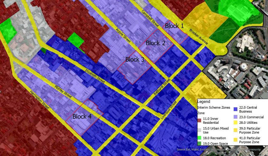
Figure: Proposed Central Business Zone extension
An analysis of the rezoning is provided below under Appendix C Central Business Zone review of the Draft LPS Supporting Report:
Appendix C - Central Business Zone review(PDF, 265KB)
You can find out more information about the Central Business Zone under HOB-S6.0 Hobart Commercial Zone SAP of the Draft LPS Supporting Report:
Draft LPS Supporting Report(PDF, 375KB)
You can also search for your address in the interactive map to see which land use zonings or specific provisions apply to you: Proposed Tasmanian Planning Scheme Local Provisions Schedule map
Why is the Active Frontage Overlay being extended?
The Active Frontage Overlay is an overlay of the Central Business Zone that controls building design and uses at the ground floor level to encourage interest and engagement for passing pedestrians in key city streets.
It is proposed that the overlay is extended further north along Elizabeth Street, to include the area between Brisbane Street and Warwick Street. This area is an important link between the centre of the city and the North Hobart retail and restaurant strip. It is an area well frequented by pedestrians and cyclists and it is important that future use and development in this area is engaging and active at street level.

Figure: Proposed Active Frontage Overlay extension
An analysis of the Active Frontage Overlay extension is provided below under Appendix I Active Frontage overlay review in the Draft LPS Supporting Report:
Appendix I - Active Frontage overlay(PDF, 557KB)
You can find out more information about the Frontage Overlay and its requirements under the HOB-S6.0 Hobart Commercial Zone SAP of the Draft LPS Supporting Report:
Draft LPS Supporting Report(PDF, 375KB)
You can also search for your address in the interactive map to see which land use zonings or specific provisions apply to you: Proposed Tasmanian Planning Scheme Local Provisions Schedule map
Will there be maximum building heights in the CBD?
The Hobart draft LPS includes a Central Business Zone Specific Area Plan which carries forward similar provisions to the Central Business Zone under the Hobart Interim Planning Scheme 2015.
The Central Business Zone Specific Area Plan does not include absolute maximum building heights, and does not implement the recommendations of the Leigh Woolley Building Height Standards Review Project(PDF, 119MB).
Council resolved to consider these issues as part of the Central Hobart Plan.
Flood-Prone Areas Hazard Code
A short presentation on the Flood-Prone Areas Hazard Code can be viewed here:
Flood-Prone Areas Hazard Code Short Presentation
Why is there a new Flood-Prone Areas Hazard Code and mapping?
All Councils are required to identify flood prone areas within their municipality as part of good strategic planning, and as a requirement of the Urban Drainage Act 2013 which specifies that the City of Hobart must identify the level of risk from flooding for each catchment in the public stormwater system.
This mapping considers known areas at risk of flooding, but also models areas of the municipality where flooding may occur when considering the impacts of climate change, or storm surge events. Find more information on the storm surge and flood prone land, you can find more information at:
City of Hobart has undertaken flood and inundation prone areas mapping in 2013, 2014 and 2019. These maps can be viewed here:
Flood maps
This existing mapping is not new, the City of Hobart is informing those who may be affected by the possibility of flooding and encouraging them to become more aware and seek further advice regarding flood risk.
- Further information on flood depths, velocities and hazard ratings for specific properties can be requested from the City of Hobart to assist residents in assessing their property's risk. This more detailed information is available for a fee. Further information can be found on the understanding flood risk page.
What are the current planning requirements for development in flood-prone areas?
This mapping currently applies under the Hobart Interim Planning Scheme 2015, if there is development on land subject to the risk of riverine flooding (E15.2.1 (c)). At the moment, and for a number of years, if you apply for a development and the mapping shows you may be at risk of flooding, you may need to obtain an Inundation prone areas hazard management assessment, to determine whether the building design may require modifications to protect it from flooding or show other works to ensure that additional flooding isn't caused on adjoining properties from your development.
- Planning requirements only affect new developments that have not yet gone through the planning approval process, existing residences will not be subject to any retrospective assessment.
The City of Hobart intends to incorporate the Flood-Prone Areas Hazard Code and overlay mapping within the Hobart LPS, to make it clear to all landowners as to where it applies. Similarly to now, if you are proposing a development at your property, you may need to get an additional assessment completed to ensure that the development will be safe from flooding into the future.
If my property is outside the Flood-Prone Areas Hazard mapping, does it mean my property will never be flood affected?
Just because your property is not within the flood-prone areas hazard mapping it does not mean it won't be affected in a flood. If your property is within the flood-prone areas hazard mapping, or the City of Hobart has reason to believe it may be subject to flood, the Flood-Prone Areas Hazard Code will still apply.
Specific areas and other considerations
What is the Lower Sandy Bay Escarpment Specific Area Plan?
The Lower Sandy Bay Escarpment Specific Area Plan is a new specific area plan that translates provisions from the Hobart Interim Planning Scheme 2015 that currently apply to the area in the Low Density Residential Zone.
It includes provisions relating to the siting of buildings close to the escarpment, site coverage and lot design. The terminology and format of provisions relating to this area have been amended to be consistent with the Tasmanian Planning Scheme.
The principal change to the provisions in this area is the applicable lot sizes. Under the Hobart Interim Planning Scheme 2015, the permitted lot sizes for land between Cartwright's Point and Blinking Billy Point is 520m2 for a lot with an average slope less than 20 per cent gradient, and 750m2 for a lot with an average slope of greater than 20 per cent gradient.
Under the Hobart draft LPS, minimum lot size is determined through the State Planning Provisions in the Low Density Residential Zone, which is 1500m2. This is considered to be a more appropriate lot size for this area and should not result in additional development potential.
For more information, see the HOB-S3.0 Lower Sandy Bay Escarpment SAP section of the Draft LPS Supporting Report(PDF, 375KB).
What is happening to the Sullivans Cove Planning Scheme 1997?
As each municipal area is allowed only one LPS, the provisions currently applying to the Sullivans Cove area under the Sullivans Cove Planning Scheme 1997 need to be translated into the Hobart draft LPS.
Th translation of provisions of the Sullivans Cove Planning Scheme 1997 have been primarily done through new particular purpose zones under the Hobart draft LPS. The particular purpose zones largely translate the existing provisions, although they have been altered to fit the structure and drafting conventions of the Tasmanian Planning Scheme.
Most of the Sullivans Cove area will be covered by the Particular Purpose Zone - Sullivans Cove(PDF, 375KB). Macquarie Point will have its own Particular Purpose Zone - Macquarie Point(PDF, 375KB), based on the existing Site Development Plan under the Sullivans Cove Planning Scheme 1997.
There are however some changes affected Sullivans Cove. These include:
Places of cultural significance listed under the Sullivans Cove Planning Scheme 1997 have also been translated across to the Hobart draft LPS by using the local heritage and archaeological potential places and precincts.
What will happen at Macquarie Point?
Macquarie Point is currently subject to the provisions of the Sullivans Cove Planning Scheme 1997 which includes a specific Site Development Plan for the site.
These provisions are carried forward into the Hobart draft LPS as a new Particular Purpose Zone.
The Particular Purpose Zone - Macquarie Point(PDF, 375KB) translates the provisions of the existing Site Development Plan under the SCPS 1997, except for some adjustments to the use table to ensure the uses align better with the Tasmanian Planning Scheme use classes.
The Hobart draft LPS does not include any reference to a proposed stadium on the site.
Will the Hobart LPS change the University of Tasmania (UTAS) Sandy Bay Campus zoning or impact any proposed plan to move in any way?
The UTAS Sandy Bay campus is currently subject to a Particular Purpose Zone under the Hobart Interim Planning Scheme 2015. The Hobart draft LPS translates these provisions directly across from the Interim Scheme and no strategic changes are proposed as part of this process.
What is happening to the changes to Short Stay Visitor Accommodation?
The Council's policy position on short stay visitor accommodation has changed since the Hobart draft LPS was initiated and as such, the Council's proposed restriction on whole dwelling short stay visitor accommodation in residential zones is not included.
It should be noted that the State Planning Provisions do not restrict whole dwelling short stay visitor accommodation in residential zones.