Flood risk and maps
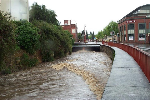
Because of the location between Kunanyi / Mt Wellington and the Derwent Estuary, Hobart is prone to flash flooding. Flash floods are characterised by fast rising and fast receding water. Flood waters are often shallow but fast moving.
When a high tide occurs at the same time as an extreme rain event, flooding can be even worse.
Most residents of Hobart are familiar with our major waterways. These include Hobart, New Town and Sandy Bay rivulets. These waterways always water flowing in them and they have high natural amenity. You may be unaware of the minor waterways or natural drainage lines. Many of these have been piped, and many are dry for some or all of the year. Some of the minor natural drainage lines may only have water flowing in them in extremely heavy rainfall events.
Because these minor drainage lines are not obvious, many parts of the city have been built across them. You may not be aware that your property may be in a natural pathway for water.
Your property may be at risk of flood damage if:
- you are near a waterway, including ephemeral waterways that are usually dry, and waterways that are fully piped underground
- your property is in a natural depression, including at a dip in the road
- your property slopes up into natural bushland
- your property is in a low-lying area near the Derwent River.
Floods can occur at any time of the year regardless of the season. In the last few years our biggest events were in May and December.
Flood maps
The City of Hobart has commissioned a number of flood studies for the municipality, including:
- city wide 1% AEP (1-in-100 year flood) flood mapping. This is broad scale flood modelling used to approximate flood extents through overland flow paths at a whole of catchment scale
- detailed rivulet analyses on the three main open watercourses (Hobart Rivulet Flood Study 2013, Sandy Bay Rivulet Flood Study 2014, and New Town Rivulet Flood Study 2019).
The flood maps are a consolidation of the various flood studies. They show the drainage lines and natural flood ways where flood water is predicted to travel through the city during a 1% AEP event (1-in-100 year flood).
View the flood maps
The modelling has been done at a catchment wide level. It provides an indication of potential hazards but may not be accurate at a property level. Seek independent advice for your site-specific flood risk.
The modelling identifies major flow paths during extreme events. It does not pick up localised nuisance flooding associated with undersized pits or pipes or localised road camber. It also does not pick up un-concentrated sheet flow, such as what occurs at the bush-urban interface. Just because your property is not within the mapped hazard extent does not mean you won't be affected in a flood.
Our role in mitigating flood risk
Before a flood
- Model and map flood risk.
- Statutory planning in flood risk areas.
- Maintain a flood alert system on major rivulets.
- Maintain flood mitigation measures such as debris irons and boulder traps.
During a flood
- Keep the pipe system clear of blockages.
- Keep debris irons and boulder traps clear of large debris.
- Respond to customer requests about blockages with the existing infrastructure.
After a flood
- Clear debris from waterways, roadways, and parks.
- Repair damaged assets.
Property owner's role in mitigating flood risk
Before a flood
- Know and understand the likely flood risk at your property.
- Ensure that you have adequate insurance, including coverage for all parts of your property likely to be affected. This includes fences and outbuildings.
- Prepare a flood response plan.
During a flood
- Move valuable and hazardous possessions to higher levels.
- Follow your flood response plan.
- If evacuating, do not return home until you have been advised it is safe to do so.
- Call the SES on 132 500 if you are in immediate danger.
After a flood
- Contact your insurance company if there has been damage to your property.
- Check in with your neighbours.